leaving the grand canyon / mesa verde cliffs
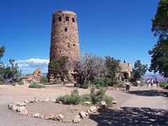 |
the way it looks it could have been something built by natives peoples as a temple to the sun or an outlook on the terrain, you know to track game or something. but, the first plaque lays it all out, this building was designed and built in the 1930's, it isnt a replica of any specific building but it is meant to fit right in. personally, i would have rather them lie to me and tell me it was 700 years old. something that is surprising, however, is that most of the historic buildings built
 |
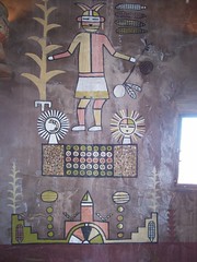
the views from that tower were quite spectacular, the inside had been painted by a native, depicting native scenes and was overall very well done. you could see the colorado river very well from the landing and it afforded a great scope for the magnificence of the earth. also, there was a snake there, coiled up right outside the visitors center. that was pretty neat.
after that, i made my way to the exit. something about this day, i spent the most money yesterday that i have in one day on this trip. at the exit i pulled up and
 |
the way out of the main national park area offered the view of the canyon that i had expected upon arriving. it was much more a sheer drop, a plateau and then a sheer drop to the colorado river. something more like my vision of just being able to stand on a precipice and look down at the raging colorado. i wanted to stop and take a photo, but i didnt. i didnt do what i wanted to do.
there isnt much to the immediate east of the main grand canyon. i drove in relative desert with plateaus and mesas in the distance for about 50 miles, when i reached the crossroads of highway 89 and 160. that is where my turn would be. from 89 north to 160 east. steve had pointed out this intersection to me and sent me a photo of it, it is a northern area of the painted desert. so, instead of just
 |
around this time my good/old friend adam called me and we chatted for a bit. i will see him when i get to boulder, only a short while before he leaves for portland. what a coincidence.
again, i shouldve taken more pictures, but i was running quite low on gas and was nervous to start and stop a number of times for how much fuel that would burn off. eventually i came to the community of keyanta and got gas, which cost about $40...pushing my daily total to about $110. i looked at the map and saw that the entire area that i was driving through and would drive through was navajo reservation. it is sad to see the box that the imperialists forced the natives
 |
that is where the four corners of the states utah, colorado, arizona and new mexico meet each other. it is on navajo land, and justly they charge a fee for people to come and take pictures. i found it strange that i had been traveling for 36 days and had only been in three states. yesterday i doubled my state total in just a few moments...but that is for another time, i have special plans for an entry all about state lines and borders in general.
i had already gotten further than i wanted to that day, so i charted a course for
 |
that done, i was ready to sit down and have a drink. i looked around for a nice divey bar. no such luck. the bars on the main street were all sit down restaurants/bars and predominantly for bikers. i dont have anything against biker bars, but i wanted to sit at a bar and just nurse a beer for a bit, not be in a restaurant. eventually i didnt find anything. so i bought some food and ate it in a large park, then pushed off to find a place to park for the night.
today i looked around for some kind of festival or happening this weekend in cortez or durango (the next big town) where i could go sit for a couple of hours and try to sell some necklaces, but no such luck. just a rodeo and a car show. so, i left
 |
however, once i got to the park it was 20 miles driving in until i got to anything. i didnt know what mesa verde was coming into it. i just saw it was the next national park and i had this nifty free pass to all national parks, time to use it. quickly i found out that it is a preserved site where pueblo people used to live. pueblo, cliff dwellers, awesome.
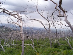
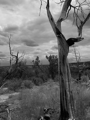
i drove in for awhile, through 100's of acres of what appeared to be petrified forest, but in reality is just the remnant forest from a large forest fire in 2000. most of this park burned from 1996-2000 in about 5 major fires over 30,000 acres of the park burned. it creates a wonderful effect.
there are three tours through cliff dwellings here that you have to pay for. there are two main section of the park, one of them employs a tram that takes you to the top of a cliff where you go on a guided tour of one of the dwellings. it costs $3,
 |
unfortunately, there isnt really any hiking in this park, probably as a preservation tactic for the various ruins. i drove and parked at various sites, took a bunch of photos and reveled in awe at the wonder of these places. eventually i came upon the first paid tour area. i walked up behind one of the tours and listened to the talk the ranger was giving, when he finished he said for people to follow him down this large flight of stairs and he would take tickets at the bottom. bummer. so i waited till they got through, went down the stairs and tried to follow, but padlocked and barbed wire.
so i pushed on.
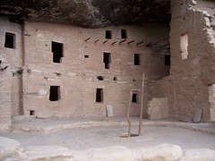 |
not long after that i came to the second paid tour. same routine, came up behind a group that had just gone in, listened to the ranger talk, then we are going down a flight of stairs. he didnt mention about grabbing tickets so i joined the throng and went down the stairs. success! i went on the balcony house tour for free. apparently it is the most strenuous tour of the three. and it offered some pretty amazing stuff.
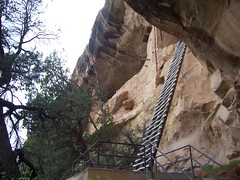
for one, after the first area we had to climb about a fifty foot ladder to get to the actual dwelling area. that was great, then we had some talks there and looked around. we had to climb another short ladder and go through a crevice behind the houses to get to the third area where the kiva's were.
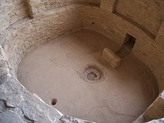
kiva's are pits dug out about 10 feet deep and then roofed with wood and thatch and then covered with stone so they are level with the walking area. they are religious places, complete with a path to the underworld that has a small stone over it so no one falls in. the ranger gave his longest talk, which got a bit religious itself,
 |
then we went to leave the balcony house. however, to get out we had to squeeze through a tiny tunnel. and i mean tiny. my ass had to wiggle through a bit, i am not a huge person, but looking at it i was nervous about getting stuck. i made it into the tunnel after the wiggle and it opened up into a tall cavern and then quickly closed back down into a tiny door that i again had to wiggle through. then we had to climb another ladder about 50 feet and walk across footholds in the the sandstone to another 50 foot ladder to the exit.
i thought it was fun, and i was quite surprised how many people there were that made it without any real problems. it wasnt the fittest bunch of people, some had big backpacks and one couple each had a baby on their back. i wondered how they made it through the tunnel. then i left for more driving and stopping, sightseeing, pictures and binocs. i was starting to get quite tired of it, the starting and stopping, so i decided to push on towards the lodge where i would find my rest for the night. one thing i hadnt counted on was that i hit back into central time zone sometime yesterday. so it is an hour earlier than i had thought.
i will spend the night here, explore more tomorrow and then decide to stay another night or move on again. also, i love life.


0 Comments:
Post a Comment
Subscribe to Post Comments [Atom]
<< Home